
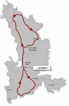
The route starts and ends at Ljungars (Sarvisalontie 1164).
From Ljungars the route goes north along the main road. In the north end of Sarvsalö the route turns to the left towards Bredvik. From there the route goes past Bredvik back down to Ljungars.
Back at Ljungars is the switch for the couples relay.
From Ljungars the route goes straight south along the main road. In the south end of Sarvsalö the route turns to the right towards Horslök.
From Horslök the route goes straight back up to Ljungars and the finish line.
Depending on the way of measuring the route (GPS, Peugeot and Saab) we got different results considering the length of the route (20,4-20,8 km), but we still think it's close enough...
We have recorded the route using Sports Tracker. You can view the route directly on Google Maps or download it in the following formats:
Keyhole Markup Language v2.2(.kml)
GPS eXchange Format v1.1 (.gpx)
We have also created an altitude profile from the GPS data (shown below). Click on the picture to see a larger image.

This way, please!